El Nino / La nina / Neutral
-
JL

- Posts: 2610
- Joined: Thu May 22, 2003 8:57 am
- Location: Saanichton / Shirley (French Beach)
- Been thanked: 2 times
- Contact:
Whimpy El Nino:
http://cliffmass.blogspot.ca/2014/10/wimpy-el-nino.html  "The latest NWS Climate Forecast System forecasts for December-January-February is for warmer than average over much of the U.S. No hint of the feared "polar vortex.""
Thermals are good.
-
JL
- Posts: 2610
- Joined: Thu May 22, 2003 8:57 am
- Location: Saanichton / Shirley (French Beach)
- Been thanked: 2 times
- Contact:
4 December 2014
ENSO Alert System Status: El Niño Watch
Synopsis: There is an approximately 65% chance that El Niño conditions will be present during the Northern Hemisphere winter and last into the Northern Hemisphere spring 2015.
During November 2014, sea surface temperature (SST) anomalies increased across the central and eastern equatorial Pacific (Fig. 1). At the end of the month, the weekly Niño indices ranged from +0.4oC in the Niño-1+2 region to +1.0oC in the Niño-3.4 region (Fig. 2). The subsurface heat content anomalies (averaged between 180o-100oW) also increased during November (Fig. 3) as a downwelling oceanic Kelvin wave increased subsurface temperatures in the central and eastern Pacific (Fig. 4). However, the overall atmospheric circulation has yet to show a clear coupling to the anomalously warm waters. The monthly equatorial low-level winds were largely near average, although weak anomalous westerlies appeared in a portion of the eastern tropical Pacific. Upper level easterly anomalies emerged in the central and eastern tropical Pacific during the month. The Southern Oscillation Index has been somewhat negative, but the equatorial Southern Oscillation Index has been near zero. Also, rainfall continued to be below average near the Date Line and over Indonesia, and near average east of the Date Line (Fig. 5). Although the SST anomalies alone might imply weak El Niño conditions, the patterns of wind and rainfall anomalies generally do not clearly indicate a coupling of the atmosphere to the ocean. Therefore, despite movement toward El Niño from one month ago, the combined atmospheric and oceanic state remains ENSO-neutral.
Similar to last month, most models predict SST anomalies to be at weak El Niño levels during November-January 2014-15 and to continue above the El Niño threshold into early 2015 (Fig. 6). Assuming that El Niño fully emerges, the forecaster consensus favors a weak event. In summary, there is an approximately 65% chance of El Niño conditions during the Northern Hemisphere winter, which are expected to last into the Northern Hemisphere spring 2015 (click CPC/IRI consensus forecast for the chance of each outcome).
This discussion is a consolidated effort of the National Oceanic and Atmospheric Administration (NOAA), NOAA's National Weather Service, and their funded institutions. Oceanic and atmospheric conditions are updated weekly on the Climate Prediction Center web site (El Niño/La Niña Current Conditions and Expert Discussions). Forecasts are also updated monthly in the Forecast Forum of CPC's Climate Diagnostics Bulletin. Additional perspectives and analysis are also available in an ENSO blog. The next ENSO Diagnostics Discussion is scheduled for 8 January 2015. To receive an e-mail notification when the monthly ENSO Diagnostic Discussions are released, please send an e-mail message to: .
Climate Prediction Center
National Centers for Environmental Prediction
NOAA/National Weather Service
College Park, MD 20740 http://www.climate.gov/news-features/de ... t/8443/all
Thermals are good.
-
JL
- Posts: 2610
- Joined: Thu May 22, 2003 8:57 am
- Location: Saanichton / Shirley (French Beach)
- Been thanked: 2 times
- Contact:
50+ % El Nino: http://www.cpc.ncep.noaa.gov/products/a ... sodisc.pdf ... http://www.cpc.ncep.noaa.gov/products/a ... ts-web.pdf
Thermals are good.
-
JL
- Posts: 2610
- Joined: Thu May 22, 2003 8:57 am
- Location: Saanichton / Shirley (French Beach)
- Been thanked: 2 times
- Contact:
70% chance of EL NIÑO continuing through this Summer: http://www.cpc.ncep.noaa.gov/products/a ... odisc.html ... http://www.climate.gov/news-features/category/98/all
Thermals are good.
-
JL
- Posts: 2610
- Joined: Thu May 22, 2003 8:57 am
- Location: Saanichton / Shirley (French Beach)
- Been thanked: 2 times
- Contact:
Meteorologist from Wash. has some input: http://cliffmass.blogspot.ca/2015/04/is ... oming.html
Thermals are good.
El Nino
Hey JL,
So no Mt Baker pass next year. Dang! They are offering next year's passes to us existing passholders at 30% off if no snow base by mid Dec.
This last year was f'ed up there. I got in 60 days, lots a Mt Hood though. Only 1 powder day. It preciped a lot, always 2 - 4 degrees too warm and we got rain in February instead of the usual deep snow. I ended up snowboarding and trying to learn tele as it was so bad. And no backcountry.
Anyways, who cares about next winter.....does El Nino mean good windsurfing this summer?
K
-
JL
- Posts: 2610
- Joined: Thu May 22, 2003 8:57 am
- Location: Saanichton / Shirley (French Beach)
- Been thanked: 2 times
- Contact:
http://cliffmass.blogspot.ca/2015/06/a- ... -does.html "The bottom line is that El Nino, and particularly a strong El Nino, heavily weights the atmospheric dice for a less stormy, warmer, and a bit drier Pacific Northwest. But nothing is certain and the impacts will depend on whether the El Nino ends up moderate or super strong."
Thermals are good.
-
thankgodiatepastafobreaky

- Posts: 512
- Joined: Tue Jul 13, 2004 5:55 pm
- Location: Gordon's
- Been thanked: 1 time
- Contact:
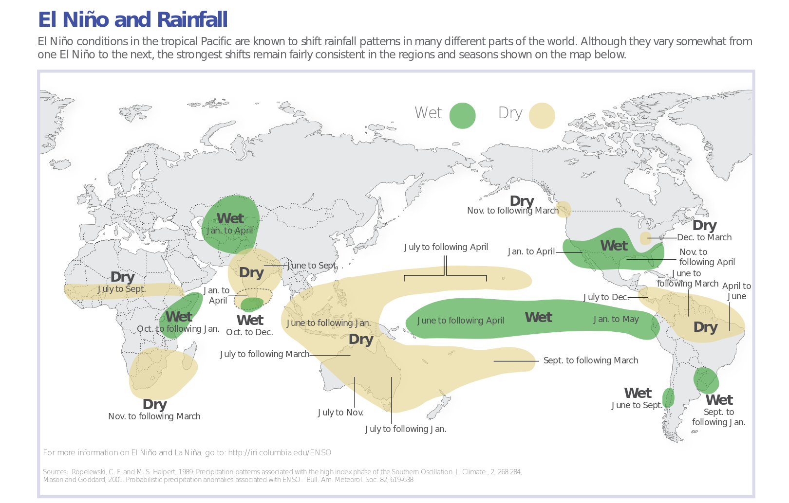
It seems that this season's El Niño will likely cause a dryer winter here and a wetter winter in southern Baja again. Here is a good visual:
https://www.climate.gov/sites/default/f ... ap_lrg.png
https://www.climate.gov/sites/default/f ... ap_lrg.png
curses - foiled again!
 ...
... 
-
mortontoemike

- Posts: 513
- Joined: Sun May 02, 2004 3:08 pm
- Location: Sometimes here (Van)... sometimes there (Nanoose)
- Contact:
Re: El Nino
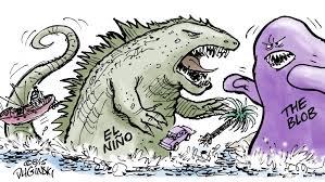
Hey KC, if you read the Godzilla (el Nino) vs The Blob (warm NE Pacific) article, Godzilla wins, cools the NE Pac., and produces a near normal winter snowpack - 20% below standard. Not that bad. Time to buy 3 or 4 pairs of new skis.KC7777 wrote:Hey JL,
So no Mt Baker pass next year. Dang! They are offering next year's passes to us existing passholders at 30% off if no snow base by mid Dec.
This last year was f'ed up there.
K
I wish my TOW was longer!
-
thankgodiatepastafobreaky
- Posts: 512
- Joined: Tue Jul 13, 2004 5:55 pm
- Location: Gordon's
- Been thanked: 1 time
- Contact:
Yes -great blog.
I would think that the advection where the blob is, or normally cool water during El Nino, could just cause a shift in the subsidence pattern so the air mass will fall and cool in another location. The warm blob isn't battling the equatorial warm water band. Neither is going anywhere, and so the circulation will shift to find cooler water for the falling air. It's very unpredictable with all of this heat energy ready to move.
That storm we just had was unprecedented if you read his articles on that too.
curses - foiled again!