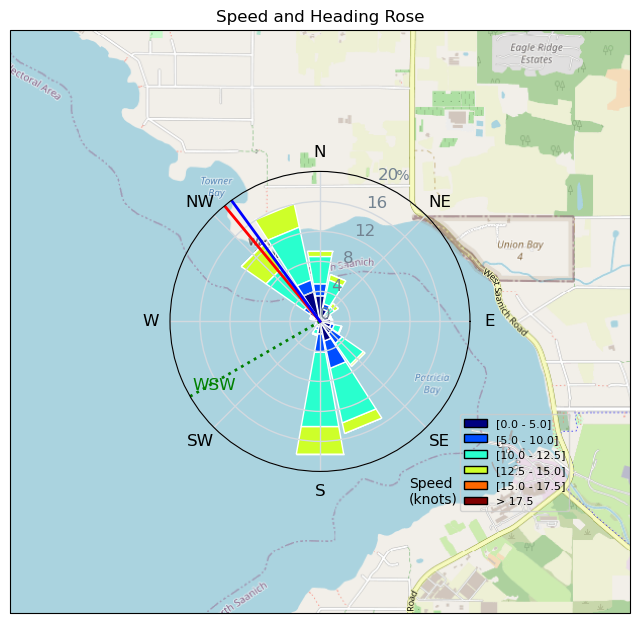
Legs
AJSpencer - Wingfoiling |
Saturday June 17, 2023 5:00 PM |
| Spot | Pat Bay |
| Conditions | W 15-25, pretty flat |
| TOW | 2.0 hours |
| Toys | 105 Axis Mast |
| 1010 Axis PNG | |
| 4.0 Duotone Slick | |
| 105 Quatro Wing Drifter | |
| Details | With insufficient Bobson OSR data at Ross, went to Pat Bay for a great session. Did some long legs out to, fortunately, decent wind outside, although was underpowered on the 4m most of the time. Gusting 25 but usually 15-20. But happy with my light wind 4m with that big 1010png foil. Went all the way past end of Wain Rd. then was going to go all the way to Yarrow Pt but looked light over there at that time. Went back in and did gybe practice. Landed a couple gybes and footswitches from port to starboard but not even close still on the starboard to port. Switch feet before or after? Fun times and making progress. [from Sailing Log on Saturday June 17, 2023] |
Speed (3s average)
| Speed | knots | km/h |
|---|---|---|
| Avg overall | 8.8 | 16.3 |
| Avg in motion | 9.7 | 18.0 |
| Max | 15.2 | 28.1 |
| Max 100m | 14.4 | 26.7 |
| Max 250m | 14.0 | 25.8 |
| Max 500m | 13.8 | 25.6 |
| Max 2s | 15.1 | 28.0 |
| Max 10s | 14.6 | 27.0 |
| Max Alpha (500/50m) | 8.8 | 16.3 |
| Avg Foiling | 11.0 | 20.4 |
Times and Duration
| Start | Sat Jun 17, 5:00 PM |
| End | Sat Jun 17, 6:54 PM |
| Duration | 01:53:29 |
| In motion | 01:42:30 |
| Paused (< 3 km/h) | 00:10:44 |
| Foiling | 01:25:13 |
| Not Foiling (< 8 km/h) | 00:28:01 |
| Last Calculated | Sat Jun 17, 7:59 PM |
Track Information
| Distance | 30.8 km |
| # Trackpoints | 6701 |
| Avg Trackpoint distance | 4.6 m |
| Number of Turns | 48 |
| Foiling Turns (> 8 km/h) | 7 |
| Foiling Turn Percentage | 15% |


Category: Wingfoiling
one year ago

Created one year ago
AJSpencer |
Please register/login to download this track.
This track was downloaded 1 time(s). |
Please wait while loading suggestions..
Please wait while loading suggestions..
You must login to post comments.