231013 Cattle Point
Highrocker - Wingfoiling |
Friday October 13, 2023 10:09 AM |
| Spot | Cattle Pt |
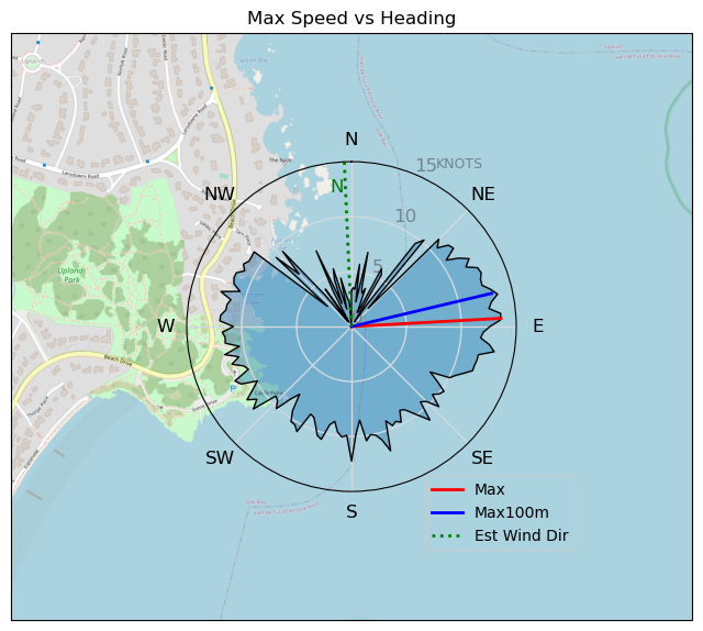
| Conditions | NE 10-17, Mostly flat |
| TOW | 2.0 hours |
| Toys | 2050sqcm Axis 1020mm Carbon Front Wing |
| 750mm Axis Aluminum Mast | |
| 6m Cabrinha X3 Windows | |
| 6.2m Cabrinha Mantis | |
| Details | One of my best sessions ever at Cattle Pt with MtnarG, Paul, Lancer, Bobson, Tweezer, Ruppdog, and WindMD. Wonderfully flat water let you do whatever you wanted. Lots of gybe successes. Lots of close quarters maneuvering that was exhilirating. Got some footage of the OGs on foil and played gybe games with the elite foilers! Hard to beat! Started on 6.2m and got immediate, easy lifts - but was often overpowered and tired me out quickly. Switched to 6mX3 and that worked well. Today's winds were such an unexpected treat - like finding a random $20 in the pocket of an old wing bag! Sweet! [from Sailing Log on Friday October 13, 2023] |
Speed (3s average)
| Speed | knots | km/h |
|---|---|---|
| Avg overall | 3.8 | 7.1 |
| Avg in motion | 7.7 | 14.3 |
| Max | 13.6 | 25.2 |
| Max 100m | 13.2 | 24.4 |
| Max 250m | 12.5 | 23.2 |
| Max 500m | 10.9 | 20.1 |
| Max 2s | 13.6 | 25.2 |
| Max 10s | 13.2 | 24.4 |
| Max Alpha (500/50m) | 10.6 | 19.7 |
| Avg Foiling | 8.8 | 16.3 |
Times and Duration
| Start | Fri Oct 13, 10:09 AM |
| End | Fri Oct 13, 1:27 PM |
| Duration | 03:18:11 |
| In motion | 01:38:29 |
| Paused (< 3 km/h) | 01:37:35 |
| Foiling | 01:15:29 |
| Not Foiling (< 8 km/h) | 02:00:35 |
| Longest Foiling Segment | 00:07:40 (2.3 km) |
| Last Calculated | Fri Oct 13, 8:23 PM |
Track Information
| Distance | 23.5 km |
| # Trackpoints | 2571 |
| Avg Trackpoint distance | 9.1 m |
| Number of Turns | 117 |
| Foiling Turns (> 8 km/h) | 64 |
| Foiling Turn Percentage | 55% |


Category: Wingfoiling
one year ago

Created one year ago
Highrocker |
Please register/login to download this track.
This track was downloaded 0 time(s). |
Please wait while loading suggestions..
Please wait while loading suggestions..
You must login to post comments.