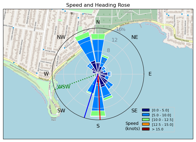
231203 Ross Bay
Highrocker - Wingfoiling |
Sunday December 03, 2023 1:45 PM |
| Spot | Ross Bay |
| Conditions | W 15-22, chop to 1m swell |
| TOW | 1.0 hours |
| Toys | 900mm Axis Aluminum Mast |
| 750mm Axis Aluminum Mast | |
| 6.2m Cabrinha Mantis | |
| 115L JP Australia Foil Pro | |
| Details | Persistence rewarded! It felt like I was chasing the wind all day. Started at Willows - too big a shorebreak. Then Cad Bay - big wind and shorebreak. Tried Elk Lk - nothing. Tried RB - big waves/shorebreak. Just flew my drone. Went shopping at Canadian Tire. Got another good RB OSR. Arrived at RB and everyone was just hanging ashore waiting for wind. I rigged big in case the winds came. Good thing as I ended up with a good hour session with some valuable mast positioning advice from the Doc! [from Session Log on Sunday December 03, 2023] |
Speed (3s average)
| Speed | knots | km/h |
|---|---|---|
| Avg overall | 5.0 | 9.3 |
| Avg in motion | 7.2 | 13.4 |
| Max | 13.2 | 24.4 |
| Max 100m | 12.0 | 22.2 |
| Max 250m | 10.9 | 20.1 |
| Max 500m | 10.3 | 19.1 |
| Max 2s | 13.1 | 24.3 |
| Max 10s | 12.5 | 23.1 |
| Max Alpha (500/50m) | 10.3 | 19.1 |
| Avg Foiling | 8.4 | 15.6 |
Times and Duration
| Start | Sun Dec 03, 1:45 PM |
| End | Sun Dec 03, 2:53 PM |
| Duration | 01:08:38 |
| In motion | 00:47:59 |
| Paused (< 3 km/h) | 00:19:14 |
| Foiling | 00:35:32 |
| Not Foiling (< 8 km/h) | 00:31:41 |
| Longest Foiling Segment | 00:06:45 (1.9 km) |
| Last Calculated | Sun Dec 03, 7:19 PM |
Track Information
| Distance | 10.7 km |
| # Trackpoints | 1259 |
| Avg Trackpoint distance | 8.5 m |
| Number of Turns | 44 |
| Foiling Turns (> 8 km/h) | 28 |
| Foiling Turn Percentage | 64% |


Category: Wingfoiling
12 months ago

Created 12 months ago
Highrocker |
Please register/login to download this track.
This track was downloaded 0 time(s). |
| 9 20241114 |
| 3 NewWingDay |
| 41 Sweet 700MA! |
| 29 RB Nov 11 |
| 42 Nice 1150cm2 and 5m session. |
Please wait while loading suggestions..
Please wait while loading suggestions..
You must login to post comments.