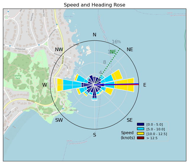
240219 Cattle Point
Highrocker - Wingfoiling |
Monday February 19, 2024 9:16 AM |
| Spot | Cattle Pt |
| Conditions | NE 8-16, 1ft rips |
| TOW | 1.0 hours |
| Toys | 900mm Axis Aluminum Mast |
| 2050sqcm Axis 1020mm Carbon Front Wing | |
| 6.2m Cabrinha Mantis | |
| 115L JP Australia Foil Pro | |
| Details | I followed Bobson's lead, albeit a bit late, and MtnarG's wisdom and took the shot on a marginal day. Glad, as there were carveable winds in the swells with WhoopSon! Tuna was considering his rec choices as I was putting in and decided on MTB vice WF. There were holes, but not many that you couldn't pump through. I nearly got sucked into Bob's Mach chicken slipstream as he ripped by me. Lancer was coming out as I was going in as the winds were reducing. Luckily, he did get some sweet jibe-friendly winds that I filmed on my RPAS (drone). [from Session Log on Monday February 19, 2024] |
Speed (3s average)
| Speed | knots | km/h |
|---|---|---|
| Avg overall | 4.4 | 8.2 |
| Avg in motion | 7.6 | 14.1 |
| Max | 12.2 | 22.6 |
| Max 100m | 11.4 | 21.2 |
| Max 250m | 11.1 | 20.6 |
| Max 500m | 10.9 | 20.1 |
| Max 2s | 12.2 | 22.6 |
| Max 10s | 11.9 | 22.0 |
| Max Alpha (500/50m) | 10.1 | 18.6 |
| Avg Foiling | 8.9 | 16.5 |
Times and Duration
| Start | Mon Feb 19, 9:16 AM |
| End | Mon Feb 19, 10:35 AM |
| Duration | 01:18:45 |
| In motion | 00:45:56 |
| Paused (< 3 km/h) | 00:30:26 |
| Foiling | 00:34:57 |
| Not Foiling (< 8 km/h) | 00:41:25 |
| Longest Foiling Segment | 00:13:17 (3.9 km) |
| Last Calculated | Mon Feb 19, 1:59 PM |
Track Information
| Distance | 10.8 km |
| # Trackpoints | 1705 |
| Avg Trackpoint distance | 6.3 m |
| Number of Turns | 42 |
| Foiling Turns (> 8 km/h) | 17 |
| Foiling Turn Percentage | 40% |


Category: Wingfoiling
9 months ago

Created 9 months ago
Highrocker |
Please register/login to download this track.
This track was downloaded 0 time(s). |
Please wait while loading suggestions..
Please wait while loading suggestions..
You must login to post comments.