Ceebee
winddoctor - Wingfoiling |
Thursday April 11, 2024 11:45 AM |
| Spot | Columbia Bch |
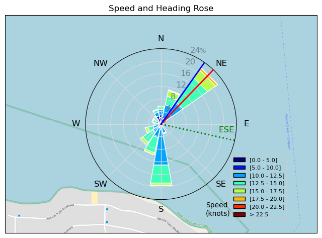
| Conditions | SE 30-35, Mixed. Some bigguns |
| TOW | 3.0 hours |
| Toys | 50cm Armstrong 50 fuse |
| 935 Armstrong Performance | |
| 205 Armstrong Surf 205 | |
| 680cm2 Armstrong HA 680 | |
| 3 KT DD | |
| 4 KT DD | |
| 72L, 4'10" KT Ginxu | |
| Details | Tweezer and I plus Shaggy made the trek to CB hoping for 20knots. We got 30+! Ultra low tide = shite walk to the ocean but once out the wind was strong and swells were fun if not large. Immediately found out that 4m was way too big. Local WS contingent out ripping on 4m - looked super fun. Decided that straps are only good for jumping on the Ginxu; I much prefer the way it rides strapless. Got some fun hops in early then took the straps off and enjoyed the carving so much more. Tweezer on a 2m, Shaggy on 2.5, all of us juiced to the gills. Some fun glides into good swell later, but the giants never really manifested today. Thanks for the drive, Tweezer! Great session. [from Session Log on Thursday April 11, 2024] |
Speed (3s average)
| Speed | knots | km/h |
|---|---|---|
| Avg overall | 8.1 | 15.0 |
| Avg in motion | 11.5 | 21.3 |
| Max | 22.2 | 41.2 |
| Max 100m | 20.0 | 37.1 |
| Max 250m | 17.2 | 31.8 |
| Max 500m | 15.0 | 27.9 |
| Max 2s | 22.2 | 41.2 |
| Max 10s | 20.0 | 37.1 |
| Max Alpha (500/50m) | 14.7 | 27.2 |
| Avg Foiling | 12.6 | 23.3 |
Times and Duration
| Start | Thu Apr 11, 11:45 AM |
| End | Thu Apr 11, 2:04 PM |
| Duration | 02:19:00 |
| In motion | 01:37:47 |
| Paused (< 3 km/h) | 00:40:50 |
| Foiling | 01:25:21 |
| Not Foiling (< 8 km/h) | 00:53:16 |
| Longest Foiling Segment | 00:13:17 (5.2 km) |
| Last Calculated | Thu Apr 11, 7:40 PM |
Track Information
| Distance | 34.7 km |
| # Trackpoints | 5690 |
| Avg Trackpoint distance | 6.1 m |
| Number of Turns | 112 |
| Foiling Turns (> 8 km/h) | 109 |
| Foiling Turn Percentage | 97% |


Category: Wingfoiling
8 months ago

Created 8 months ago
winddoctor |
Please register/login to download this track.
This track was downloaded 0 time(s). |
| 39 Swell beckons |
| 36 Clover week |
| 41 Double rainbowwww |
| 32 aCloverBalmyBombo |
| 28 Maytag day at IV 20241122 |
Please wait while loading suggestions..
Please wait while loading suggestions..
You must login to post comments.