WishfulWednesday
UnusuallyLargeRobin - Wingfoiling |
Wednesday October 16, 2024 2:49 PM |
| Spot | Ross Bay |
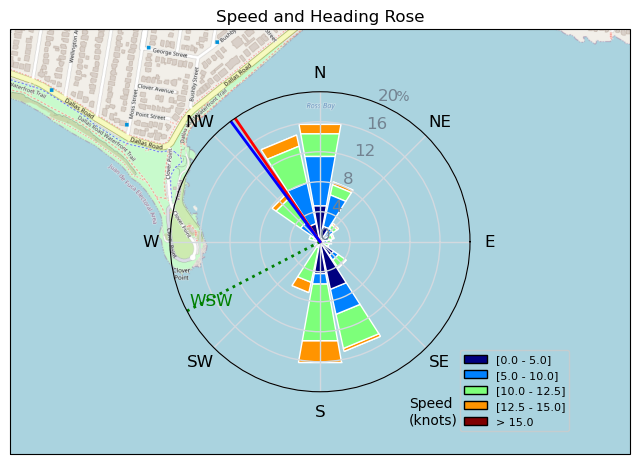
| Conditions | WSW 10-16, 1' |
| TOW | 1.5 hours |
| Toys | 75 lt Fanatic Sky Wing 5'0 |
| 5.5m Gong Neutra Team Ed | |
| 90cm Axis Alu Mast | |
| HPS 1050 (1460cm2) Axis Foil | |
| Crazy Short (60.0cm) Axis Black Advanced Fuselage | |
| 365/55 Skinny Axis Rear Foil/Stab | |
| 187 lb / 85 kg Me Carbon-based Lifeform | |
| Details | Looked good and windy on the cam so gathered up the gear and headed down to the bay. Arrived to less than stellar conditions and not a lot of the peeps flying. Everyone eventually came in and I waited around for about an hour till it came back to flying levels. RupDog and Bobson were already out so joined them in the easy, light, no wave conditions. Quite a lot of loose big healthy kelp floaties and masses about, was this a result of MF4's weed whacking? An unusually large dark cloud bank was approaching, looking like rain and maybe lightning, scampered back to the beach before it arrived and tanked the wind. [from Session Log on Wednesday October 16, 2024] |
Speed (3s average)
| Speed | knots | km/h |
|---|---|---|
| Avg overall | 8.3 | 15.5 |
| Avg in motion | 8.7 | 16.1 |
| Max | 14.7 | 27.2 |
| Max 100m | 13.4 | 24.8 |
| Max 250m | 12.9 | 23.8 |
| Max 500m | 12.1 | 22.4 |
| Max 2s | 14.6 | 27.1 |
| Max 10s | 13.7 | 25.4 |
| Max Alpha (500/50m) | 11.5 | 21.2 |
| Avg Foiling | 10.4 | 19.2 |
Times and Duration
| Start | Wed Oct 16, 2:49 PM |
| End | Wed Oct 16, 3:59 PM |
| Duration | 01:10:16 |
| In motion | 01:07:26 |
| Paused (< 3 km/h) | 00:02:40 |
| Foiling | 00:52:40 |
| Not Foiling (< 8 km/h) | 00:17:26 |
| Longest Foiling Segment | 00:24:29 (7.8 km) |
| Last Calculated | Thu Oct 17, 10:06 AM |
Track Information
| Distance | 18.1 km |
| # Trackpoints | 4209 |
| Avg Trackpoint distance | 4.3 m |
| Number of Turns | 73 |
| Foiling Turns (> 8 km/h) | 66 |
| Foiling Turn Percentage | 90% |


Category: Wingfoiling
5 weeks ago

Created 5 weeks ago
UnusuallyLargeRobin |
Please register/login to download this track.
This track was downloaded 0 time(s). |
| 20 241120 Willows |
| 23 Willows Bomb Session |
| 28 Shoot the Entrance |
| 22 CloverPartDeux |
| 13 Come back soon Bombo |
Please wait while loading suggestions..
Please wait while loading suggestions..
You must login to post comments.