Columbia Beach Weather Station
-
catman
wind chill index
A cursory exam of the equation for wind chill index (as it appears on my Unix-based computer) shows a possible source of confusion: the terms with the variable "V" are intended to show V exp 0.16 (V raised to the 0.16 power). An excellent discussion of the "new" wind chill index is found at <www.nws.noaa.gov>.
Kudos for your web site!
Kudos for your web site!
- more force 4
- Website Donor

- Posts: 1459
- Joined: Wed Oct 15, 2003 8:57 am
- Location: Victoria, BC
- Has thanked: 24 times
- Been thanked: 8 times
- Contact:
Yeah Dave and crew. If there are more weather stations going in, could one be at Nitinat? Or don't want to bother with the politics?
Mattdog, I'm curious about the formula. Technically, I thought it was not possible to ever use multiplication with temperature (except Calvin which has an absolute 0) - only addition and subtraction are valid. Maybe thats why windchill is such a loosey-goosey kind of thing?
Mattdog, I'm curious about the formula. Technically, I thought it was not possible to ever use multiplication with temperature (except Calvin which has an absolute 0) - only addition and subtraction are valid. Maybe thats why windchill is such a loosey-goosey kind of thing?
- Russian Dood
- Website Donor

- Posts: 297
- Joined: Mon May 03, 2004 11:06 am
- Location: Still here, alive and kicking
Hey , Morley
Kelvin is just Celsius with an absolute 0, therefore you certainly can manipulate with Celsius the same way. Here is how you convert F to C:
Tc=(5/9)*(Tf-32)
Tc=temperature in degrees Celsius Tf=temperature in degrees Fahrenheit
* means multiply
As you can see the the equation is linear, therefore you can manipulate with Fahrenheit the same way as you manipulate with Celsius or Kelvin.
In windchill formula either will work just fine.
But you are right, scientifically speaking you'd have to use Kelvin if you want to get right result especially when you raise temp in power
- more force 4
- Website Donor

- Posts: 1459
- Joined: Wed Oct 15, 2003 8:57 am
- Location: Victoria, BC
- Has thanked: 24 times
- Been thanked: 8 times
- Contact:
RD
Yes, you can relate F to C through a conversion, which accounts for the different 0 -- but you shouldn't multiply for most other purposes,at least not between temperatures. For instance, many people think that 30C is twice as hot as 15C - but - if you convert these two numbers to F, you will get about 90F and 60F - the larger of which is no longer twice as much as the smaller. This ratio has to be calc. from Kelvin which is about 288 and 303, so it is really only 5% warmer.
We obviously need wind!
- bwd
- Developer

- Posts: 1250
- Joined: Tue May 13, 2003 8:57 am
- Location: In a van down by the jetty
- Has thanked: 42 times
- Been thanked: 55 times
- Contact:
More weather stations
I'd love to have a weather station/webcam combo up at Nitinat but it likely won't be me doing it. I kinda got burned with the webcam, but we have a nice Columbia cam instead. We are looking into Island View (maybe somewhere down near the sailing site) and maybe Gordon's. But it's a long slow process to find a location, get the gear and put it up.more force 4 wrote:Yeah Dave and crew. If there are more weather stations going in, could one be at Nitinat? Or don't want to bother with the politics?
dave
Now That I’ve Given Up Hope, I Feel Much Better
- Russian Dood
- Website Donor

- Posts: 297
- Joined: Mon May 03, 2004 11:06 am
- Location: Still here, alive and kicking
- bwd
- Developer

- Posts: 1250
- Joined: Tue May 13, 2003 8:57 am
- Location: In a van down by the jetty
- Has thanked: 42 times
- Been thanked: 55 times
- Contact:
Weather station reading low
Hi, I've been away for a few weeks - I hope everyone is having a great holiday. Too bad about the lack of wind. Congrats to all you new loopers out there (I'll need some of that peer pressure next time on the water) and don't forget to come out for the 1st annual New Year's Day sail/get together.
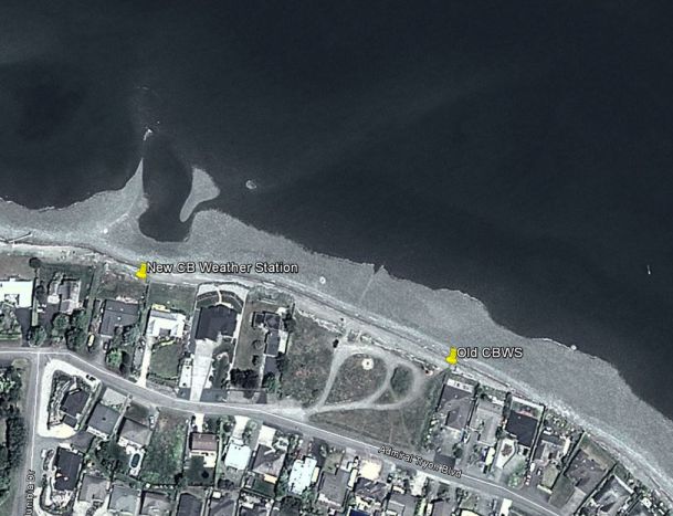
As you may have noticed, it looks like the weather station is reading low on SE winds. If you go to the weather station page and scroll down to the Wind direction Plot over time you can see that a SSE-SE wind is slightly offshore (the beach is close to the W-E line on the plot). This is great for sailing but not so good for measuring the wind since the weather station is in the lee of the houses. So we may try raising the anemometer pole another 10 feet or so.
It looks to me like the gust reading might be closer to the actual reading on the water (still low probably). Here's some approx calibrations (feel free to add your estimates):
- average of SE 12-15 (gust 15-18) is about 20 knots on the water
- average of SE 15 (gust to 20) is about 25 knots on the water
So if it's averaging over 12 and gusting over 15 then it is likely kiteable and sailable. Also the pressure change in the last 3hrs is useful - if it's > -2.5 then the SE winds are likely to increase.
dave
Last edited by bwd on Tue Jul 05, 2005 8:09 am, edited 1 time in total.
Now That I’ve Given Up Hope, I Feel Much Better
- bwd
- Developer

- Posts: 1250
- Joined: Tue May 13, 2003 8:57 am
- Location: In a van down by the jetty
- Has thanked: 42 times
- Been thanked: 55 times
- Contact:
Columbia Beach Reading on Latest Reports page
As you may have noticed I added the Columbia Beach weather station reading to the Latest Reports page. If you don't see it listed it's probably because you have to select it using the "Set Table Options" link on the Latest page. It should update every 10 mins (if you go right to the weather station page it updates every 5 mins).
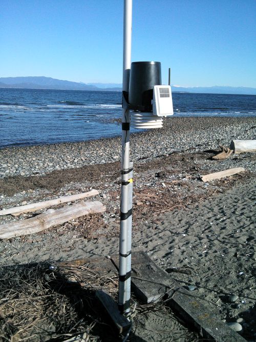
We still have to raise the wind sensor to get it to read higher in SE winds. Also the temperature sensor reads high occasionally, It's probably getting direct sunlight on it and warming up. So if you see a 22deg C reading in January don't rush out there with just your Speedo on. I'll make a little radiation shield for it and that should help.
Also the cam now has a fancy zoom on it. I was having problems with the camera so they sent me a replacement and gave me a great deal on the lens. Go easy on the zoom since it is a slow internet connection. Hopefully we can upgrade the Gordon's cam in the spring and maybe the IV cam by next fall.
dave
Last edited by bwd on Tue Jul 05, 2005 8:10 am, edited 1 time in total.
Now That I’ve Given Up Hope, I Feel Much Better
- bwd
- Developer

- Posts: 1250
- Joined: Tue May 13, 2003 8:57 am
- Location: In a van down by the jetty
- Has thanked: 42 times
- Been thanked: 55 times
- Contact:
New windspeed calculation...
Ok for all you weather geeks, others may wish to ignore this. As you know the Columbia weather station was reading low in SE winds since it is sheltered by the houses. The gusts seemed to be closer to the actual wind on the water. Previously on the Latest Table and the cam page I was giving a 10 minute average wind speed and the gust in the last 10 minutes. Now I'm trying a 1 minute gust and a 10 minute gust (ie. no averaging).
So if you see 17 gust 22 it means 17 knots was the peak in the last minute and 22 knots was the peak in the last 10 minutes. This is not the correct way of reporting winds but it might be closer to the actual, or maybe not. We'll see how it works. So the Latest Table and the Columbia Webcam page have this but the Columbia Weather station page has the averaging method. If you look at the Columbia WS page the red line is the gusts and the blue is the averaged line.
We may look into putting the station on the roof or moving it to a better site,
dave
Now That I’ve Given Up Hope, I Feel Much Better
- bwd
- Developer

- Posts: 1250
- Joined: Tue May 13, 2003 8:57 am
- Location: In a van down by the jetty
- Has thanked: 42 times
- Been thanked: 55 times
- Contact:
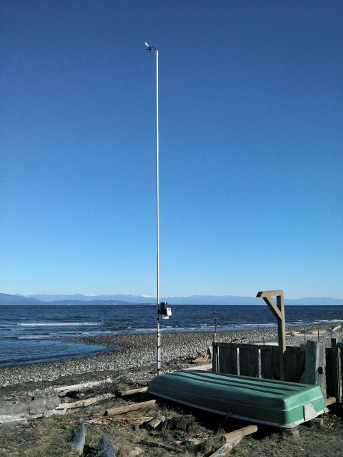
As you know by now, the CB weather station 2.0 was installed last week at a new location. The new spot is about 4 houses downwind of the launch area. There may be some wind shadowing there for a SE, but time will tell.
Huge thanks to DavidM for all of his work on this and to GWind. Big thanks to the new host Gerry and thank you to the neighbour RayP for letting us know about this location.


Huge thanks to DavidM for all of his work on this and to GWind. Big thanks to the new host Gerry and thank you to the neighbour RayP for letting us know about this location.
