GPS Tracks
-
more force 4

- Sponsor

- Posts: 1459
- Joined: Wed Oct 15, 2003 8:57 am
- Location: Victoria, BC
- Has thanked: 23 times
- Been thanked: 8 times
- Contact:
GPS Tracks
Thought you might like to see some GPS tracks overlaid on a map from Gordon's yesterday. I tried my new Garmin Foretrex 201 - supposed to we waterproof to 1 m for 30 min, we'll see.... on my short session. Theres an overview at

and a detail at
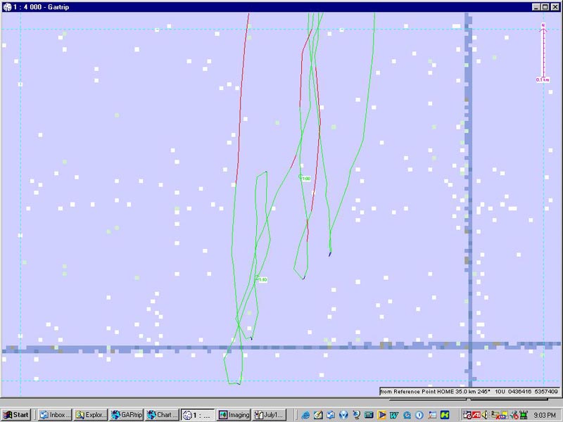
I colour coded the track segments, so
blue = less than 10 kmph, or slogging
green = 10-30 kmph, or in the straps
red= 30 kmph plus, powered up blasting
THe problem with GPS is there is no BS - you can see where you planed through a jibe -- I didn't, every one has at least a tiny bit blue. You can also see exactly how fast you go, which combined with the new BWD log means you can check out performance of different gear in similar conditions. I have software that analyses the track, so you can see at every point exactly how fast for how long you were going - the squiggly blue line is trying to waterstart in the big hole yesterday, waited 4 min and 3 sec for a puff (I almost gave up and uphauled). You can also figure out that the windline was varying between 400 and 700 m out (even planing, I can see where I tried to broad reach to keep on the plane coming in - didn't work).
The wrist-band GPS was fun on the water, with the screen set to speed display only, the numbers are about an inch high, really easy to read at a quick glance.
Once through the learning curve, and with maps set up, it only takes a few seconds to download the data and make this kind of map. Quicker if you don't bother with the map and just plot the track. Maybe overly anal and analytical but fun for us geeky guys.....
PS, kiters, you could measure just how high and long your jumps are (the Foretrex altitude yesterday seemed accurate to plus-minus 1 m, combined with the 2 d track would be enough to see just when you took off and landed those big airs).
and a detail at
I colour coded the track segments, so
blue = less than 10 kmph, or slogging
green = 10-30 kmph, or in the straps
red= 30 kmph plus, powered up blasting
THe problem with GPS is there is no BS - you can see where you planed through a jibe -- I didn't, every one has at least a tiny bit blue. You can also see exactly how fast you go, which combined with the new BWD log means you can check out performance of different gear in similar conditions. I have software that analyses the track, so you can see at every point exactly how fast for how long you were going - the squiggly blue line is trying to waterstart in the big hole yesterday, waited 4 min and 3 sec for a puff (I almost gave up and uphauled). You can also figure out that the windline was varying between 400 and 700 m out (even planing, I can see where I tried to broad reach to keep on the plane coming in - didn't work).
The wrist-band GPS was fun on the water, with the screen set to speed display only, the numbers are about an inch high, really easy to read at a quick glance.
Once through the learning curve, and with maps set up, it only takes a few seconds to download the data and make this kind of map. Quicker if you don't bother with the map and just plot the track. Maybe overly anal and analytical but fun for us geeky guys.....
PS, kiters, you could measure just how high and long your jumps are (the Foretrex altitude yesterday seemed accurate to plus-minus 1 m, combined with the 2 d track would be enough to see just when you took off and landed those big airs).
Last edited by more force 4 on Wed Jul 14, 2004 7:41 pm, edited 2 times in total.
-
~ pimp hand ~

- Posts: 277
- Joined: Fri May 21, 2004 2:19 pm
-
kitesurferdale

- Posts: 394
- Joined: Sat Nov 22, 2003 11:28 am
- Location: Port Alberni
-
more force 4
- Sponsor
- Posts: 1459
- Joined: Wed Oct 15, 2003 8:57 am
- Location: Victoria, BC
- Has thanked: 23 times
- Been thanked: 8 times
- Contact:
PH - don't know about Nobletech software, haven't heard of it. I use GarTrip, its a German guy who does it in his spare time, the commercial software didn't do what he wanted. 30 Euros for the full function, or free shareware version with limited saving capability. I remember seeing something about free Garmin software to do this, but I couldn't find it on their site.
KDale, it was $180 at Rotec communications, Bridge st. Victoria. They seemed to be the only one carrying them in this area. I thought this was a pretty good deal - same price as the little e-trex, does all the same functions, but wearable and better sealing and with a data download cable which is usually an option. Plus, you can check your truck speedo to see if its accurate (I have oversize tires, I'm lucky not to have speeding tickets cause I usually add 10k to the posted to my speedo).
Impact resist - Its rated as 5 g's to keep recording position properly, over this I presume would cause some software probs, but I imagine it would have to be a really hard knock in water to break it. Avoid onshore! Any idea how many G's are incurred in a hard fall?
Morley
-
Cindy
Foretrex
Very cool indeed. How did you overlay your map...using GarTrip or photoshop. I have been using the forerunner for my paddling training and it does have some great features but the logbook softward is pretty limited and if you don't know what to do with xml it is a pain. I will check out the Gartrip. If you are really geeky...I'm sure there is a yahoo group out there just waiting for you.
Cheers
Cindy
P.S. The Forerunner was purchased at Capital Iron for ~180$ They carry lots of Garmin products.
Cheers
Cindy
P.S. The Forerunner was purchased at Capital Iron for ~180$ They carry lots of Garmin products.
-
~ pimp hand ~
- Posts: 277
- Joined: Fri May 21, 2004 2:19 pm
hey mf4 ... yep Nobeltech has been around for a while, it's used by most vessells out there ... i have an older version of nobeltech on my boat, but i'm betting these guys have something like that now. there have been many newer versions of thier software, i'll have to poke around Nobeltech's site a bit http://www.nobeltec.com/products/default_products.asp and see.more force 4 wrote:PH - don't know about Nobletech software, haven't heard of it. I use GarTrip, its a German guy who does it in his spare time, the commercial software didn't do what he wanted. 30 Euros for the full function, or free shareware version with limited saving capability. I remember seeing something about free Garmin software to do this, but I couldn't find it on their site.
with there software you could overlay your plot on a real marine chart as opposed to a map. if you're interested, i could give you a copy.
hAppY pLoTTing

-
more force 4
- Sponsor
- Posts: 1459
- Joined: Wed Oct 15, 2003 8:57 am
- Location: Victoria, BC
- Has thanked: 23 times
- Been thanked: 8 times
- Contact:
Nobletech - I've used a couple of marine-specific versions of this kind of software on other people's boats, and had one (can't remember the name) which we used as a basic mapping tool in-house at our office for a while. We currently have Quo Vadis that does similar things, but using land-based 1:50,000 topo maps. We mostly got QV as cheap maps (all of BC for $150), we don't really use the software. The trouble with QV (and I suspect with Nobletech and the other marine navigation software) is that they will hook up to a GPS and create tracks on the fly (for an extra $150), but they won't allow downloading tracks stored in the GPS. Waypoints and routes are read/writable. Useless for windsurfing/kiting.
We use mega dollar ESRI ArcMap in-house for almost all of our mapping - you can import waypoints and the track positions from the GPS, but the relationship of each point to the adjoining ones on the track is lost, so time-speed would have to be worked out, I haven't got the time. Maybe there is a simple work-around I haven't seen yet.
GarTrip does the best job that I've seen so far, but there are probably others now. It doesn't come with maps or charts, so you have to get a bitmap of the area you are interested in and "register" it, then the GPS data shows in the right place - the QV software has an "export bitmap" function to get the image, Nobletech might do the same, then you could use the chart for your background.
-
~ pimp hand ~
- Posts: 277
- Joined: Fri May 21, 2004 2:19 pm
cool ... yeah the version i have does let me save/import/export routes, waypoints, tracks... i just have to check on my boat what the exact version is .... the color-coded speed trail is dOpe!more force 4 wrote:Nobletech - I've used a couple of marine-specific versions of this kind of software on other people's boats, and had one (can't remember the name) which we used as a basic mapping tool in-house at our office for a while. We currently have Quo Vadis that does similar things, but using land-based 1:50,000 topo maps. We mostly got QV as cheap maps (all of BC for $150), we don't really use the software. The trouble with QV (and I suspect with Nobletech and the other marine navigation software) is that they will hook up to a GPS and create tracks on the fly (for an extra $150), but they won't allow downloading tracks stored in the GPS. Waypoints and routes are read/writable. Useless for windsurfing/kiting.
We use mega dollar ESRI ArcMap in-house for almost all of our mapping - you can import waypoints and the track positions from the GPS, but the relationship of each point to the adjoining ones on the track is lost, so time-speed would have to be worked out, I haven't got the time. Maybe there is a simple work-around I haven't seen yet.
GarTrip does the best job that I've seen so far, but there are probably others now. It doesn't come with maps or charts, so you have to get a bitmap of the area you are interested in and "register" it, then the GPS data shows in the right place - the QV software has an "export bitmap" function to get the image, Nobletech might do the same, then you could use the chart for your background.
later!
-
more force 4
- Sponsor
- Posts: 1459
- Joined: Wed Oct 15, 2003 8:57 am
- Location: Victoria, BC
- Has thanked: 23 times
- Been thanked: 8 times
- Contact:


-
more force 4
- Sponsor
- Posts: 1459
- Joined: Wed Oct 15, 2003 8:57 am
- Location: Victoria, BC
- Has thanked: 23 times
- Been thanked: 8 times
- Contact:
Looked over my track from yesterday with time stamps - once I figured out how to change UCT to PDT, I've revised the sailed distance I reported in the log down from ca 100 km to about 85, looks like the GPS wasn't working for only 1/2 hour. Tried to edit the log, but got "Sorry dood, isn't ready!" message instead. Counted the jibes - about 80. No wonder I'm seeing improvement! I'll post a pic link here when I figure out how to download it to my website in Dave's absence.
New goals for summer - consistent planing jibes, duck gybe and 50+ kmph.
New goals for summer - consistent planing jibes, duck gybe and 50+ kmph.
-
more force 4
- Sponsor
- Posts: 1459
- Joined: Wed Oct 15, 2003 8:57 am
- Location: Victoria, BC
- Has thanked: 23 times
- Been thanked: 8 times
- Contact:
Found some new toys in the GPS software. Here's what 71 km of BAFfing looks like (I was just trying for speed and jibing practice, didn't try for upwind cruising). I wondered what the "graphing options" were all about, and found that "speed vs time" gave the graph at the bottom of the map. Dunno if this works without Dave's geekism, I'm trying to post to my site.

The graph is interesting. I reset red to 35 km ph from 30, since I had a pretty fast sesh. I walked around rigging for a while (blue), then sailed my old Astro Rock (green bars). Came in and tweaked stuff (blue) then went out and actually hit over 35 k with the old big board as the wind picked up. Came in (blue) and switched to smaller Adagio, then out again - only about as fast as the big board, just feels faster, higher top end? Got lots of 35 k+ and came in for a break and rigged 5.8 for Roger (next bunch of blue). The session continued with short beach breaks or swimming breaks.
The graphing is cool, if you zoom in on the map to one area, the graph shows colour only for the part you are zoomed in to, the rest of the bars go grey.
I could show a closeup of the session - massive # of runs! - if anyone wants and isn't dead bored by now.

Kiters - the graph can be set to show time vs altitude, or speed vs altitude - that might be pretty cool to see for big air. Or maybe not - I tried to see mine this way and it shows a lot of jumps I didn't do!! Elevation is the least accurate of GPS fixes.
The graph is interesting. I reset red to 35 km ph from 30, since I had a pretty fast sesh. I walked around rigging for a while (blue), then sailed my old Astro Rock (green bars). Came in and tweaked stuff (blue) then went out and actually hit over 35 k with the old big board as the wind picked up. Came in (blue) and switched to smaller Adagio, then out again - only about as fast as the big board, just feels faster, higher top end? Got lots of 35 k+ and came in for a break and rigged 5.8 for Roger (next bunch of blue). The session continued with short beach breaks or swimming breaks.
The graphing is cool, if you zoom in on the map to one area, the graph shows colour only for the part you are zoomed in to, the rest of the bars go grey.
I could show a closeup of the session - massive # of runs! - if anyone wants and isn't dead bored by now.
Kiters - the graph can be set to show time vs altitude, or speed vs altitude - that might be pretty cool to see for big air. Or maybe not - I tried to see mine this way and it shows a lot of jumps I didn't do!! Elevation is the least accurate of GPS fixes.


hey, hadn't read this thing b4, amazing stuff! where's the map info from, do you download waypoints/tracks into or does the GPS have a version and yield the print-out (forgive my ignorance is this is an obvious answer)? 
perhaps we can have virtual races overlaying these on a given, set up course, race yourself on different days, ha!
perhaps we can have virtual races overlaying these on a given, set up course, race yourself on different days, ha!
Wish less, sail more!!
Vancouver Island Windsports
Chinook /Takuma /KA Australia (Tribal) /Aztron
You're either in or in the way....
Doing things the hard way since 1963....
Vancouver Island Windsports
Chinook /Takuma /KA Australia (Tribal) /Aztron
You're either in or in the way....
Doing things the hard way since 1963....